
What are watersheds?
Every drop of rain that lands on earth goes somewhere. Some soaks into the roots of the nearest thirsty plant. Excess moisture is taken up into the atmosphere as evaporation. But not all rain lands on earth. Rooftops, sidewalks, roads and parking lots are constructed to allow water to roll right off of them.
That's actually the definition of a watershed. Any time water moves, it goes downhill. If we followed a set of raindrops after they land, their journey might look a lot like the route you'd take for a trip to Fayetteville. If you live outside town, you might start with a narrow driveway (trickle) that takes you to a dirt county road (rivulet), then on to a paved state highway (creek) and eventually to 412 heading to the city (river). You might even end up on Interstate 49 (Mississippi River!).
 Raindrops that accumulate in a puddle on a parking lot in Berryville, for instance, move down the lot to a gutter that drains through a culvert to a small urban stream, like Mill Creek, which runs down the hill next to the Berryville Community Center. Mill Creek joins with several larger streams until it reaches the Osage River. From there, that water will flow on until it joins with the Kings River west of Berryville, adding in other waterways as it goes. The Kings River begins far south in the Boston Mountains, and has already traveled many miles and gotten a lot bigger by the time our handful of raindrops reaches it. It has crossed Madison County and flowed across much of south Carroll County, looking like a beautiful green-blue ribbon.
Once our raindrops are part of the Kings River, it's like getting onto an expressway. And all along it, more feeder creeks and streams are adding volume. Soon the river begins to meet and mingle with the edges of Table Rock Lake. And there our raindrops will slowly become part of the lake. So when you swim or catch fish in Table Rock Lake, that water has come from all over the watershed to be there.
 Before Table Rock and the other big lakes in the system were created by building a series of dams, the Kings River flowed into the mighty White River, which is why The Kings River is considered to be part of the White River watershed. Ultimately, the water from the lakes is released back through the last dam and again becomes part of the White River, heading east. Eventually it will join the Mississippi. The Ozarks and all of Arkansas can be said to be part of the lower Mississippi watershed. It is composed of a group of many watersheds that all flow into the Mississippi. But it all starts with raindrops. Rain from Carroll County may just end up in the Gulf of Mexico.
Where do the raindrops that land on your house or driveway go? Becoming aware of how storm water moves on your own property is the first step towards become a better steward of our water resources. A little detective work will reveal where your property run-off is going.
Everyone lives in not just one watershed, but in a series of connected, telescoping watersheds. And the things we do as we live on our land can have a cumulative effect on the health of our shared water resources. Discovering what initial and secondary watersheds you live in can be surprising. You may live in one watershed and your neighbor in another! Still, we are connected. Understanding those connections is going to become increasingly important.
Submitted by the board of the Kings River Watershed Partnership.
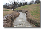
Mill Creek, Berryville AR
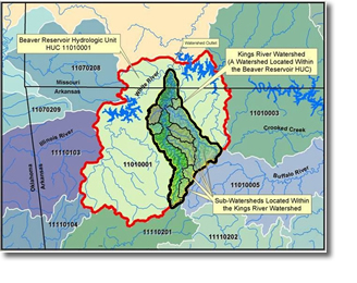
Northwest Arkansas Watersheds
P.O. Box 961 | Berryville, AR 72616 | Phone: 870-480-8897 | Email: KRWP@kingsriverwatershed.org
Site Copyright © Kings River Watershed Partnership 2007-2023. All rights reserved.
Last Update April 2023
